
Parcel 04-1N-23-0000-0005-0190
Owners
BOSHELL CONNIE ANN CO-TRUSTEE
OF BOUNDS BOSHELL TRUST
2178 TOM CRAWFORD RD
HILLIARD, FL 32046
Parcel Summary
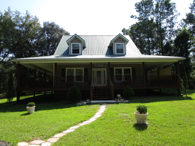
| Situs Address | 2178 TOM CRAWFORD RD |
|---|---|
| Use Code | 0100: SINGLE FAMILY |
| Tax District | 6: Drainage Dist |
| Acreage | 7.000 |
| Section | 4 |
| Township | 1N |
| Range | 23 |
| Subdivision | |
| Exemptions | HX: Homestead (196.031(1)(a)) (100%) HB: Homestead Banded (196.031(1)(ab) (100%) |
Short Legal
PT OF GOVT LOTS 9 & 10IN OR 1897/1259
Values
| 2025 Certified Values | 2026 Preliminary Values | |
|---|---|---|
| Land Value * | $136,500 | $147,000 |
| (+) Improved Value | $359,990 | $370,436 |
| (=) Market Value | $496,490 | $517,436 |
| (-) Agricultural Classification | $0 | $0 |
| (-) SOH or Non-Hx* Capped Savings ** | $264,539 | $279,222 |
| (=) School Assessed Value | $231,951 | $263,214 |
| County Assessed Value | $231,951 | $238,214 |
| (-) School Exemptions | $25,000 | $50,000 |
| (-) Non-school Exemptions | $50,722 | $51,411 |
| (=) School Taxable Value *** | $206,951 | $213,214 |
| (=) County Taxable Value | $181,229 | $186,803 |
Document/Transfer/Sales History
| Instrument / Official Record | Date | Q/U | V/I | Sale Price | Grantor | Grantee |
|---|---|---|---|---|---|---|
| WD 1897/1259 | 2013-12-17 | U | Improved | $100 | BOUNDS RONALD A & CONNIE BOSHELL | BOUNDS RONALD ALLAN & CONNIE A CO-TRUSTEES |
| WD 1861/0972 | 2013-06-07 | Q | Improved | $200,000 | BRANNEN JOSHUA WADE & NICOLE DAWN | BOUNDS RONALD A & CONNIE BOSHELL |
| WD 1449/1509 | 2006-10-04 | Q | Improved | $175,000 | MIXON JAMES C | BRANNEN JOSHUA W & NICOLE D |
Buildings
Building # 1
| Heated Sq Ft | Year Built | Value |
|---|---|---|
| 2223 | 2008 | $343,598 |
Extra Features
| Code | Description | Length | Width | Units | Unit Price | AYB | % Good Condition | Final Value |
|---|---|---|---|---|---|---|---|---|
| 0510 | GARAGE WD-MTL | 36 | 30 | 1080.00 | $35.00 | 2015 | 71% | $26,838 |
Land Lines
Personal Property
None
TRIM Notices
Property Record Cards
Disclaimer
The Nassau County Property Appraiser's Office makes every effort to produce the most accurate information possible. No warranties, expressed or implied, are provided for the data herein, its use or interpretation. The information contained herein is for ad valorem tax assessment purposes only. The Property Appraiser exercises strict auditing procedures to ensure validity of any transaction received and posted by this office but cannot be responsible for errors or omissions in the information received from external sources. Due to the elapsed time between transactions in the marketplace, and the time that those transactions are received from the public and/or other jurisdictions, some transactions will not be reflected.